


 Sähköinen kaupunkiliikenne
Lisätyt kuvat:
| Liikennemuodot: | (kaikki) · (ei määritelty) · Raitiotie · Johdinauto · Metro · Sähköbussi |
| 17.01 17:12 MSK | 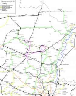 |
Map of the N.M.V.B./S.N.C.V. in and around Hasselt (province Limburg) in 1940 (non-electrified lines; green and yellow when out of the province) and 1954 (electrified lines; pink and orange when out of the province. Black = N.M.B.S./S.N.C.B. (railway). Remark: most of the electrified tramlines belonged to the Liège group (orange on the map). 1954 v. |
Valitun ajanjakson aikana lisätyt kuvat: 543
Näytetyt kuvat: 1 / 1
Näytetyt kuvat: 1 / 1
| Liikennemuodot: | (kaikki) · (ei määritelty) · Raitiotie · Johdinauto · Metro · Sähköbussi |
Tumma tila
© TransPhoton ylläpito ja kuvaajat, 2002—2024
Minkä tahansa sivuston kuvan käyttö ilman kuvaajan lupaa on kielletty.
Minkä tahansa sivuston kuvan käyttö ilman kuvaajan lupaa on kielletty.