TransPhoto

Photos are published as is and do not have purpose to promote any political and/or ideological position.

All materials are provided by users and do not reflect the opinion of the site administration team.

Close
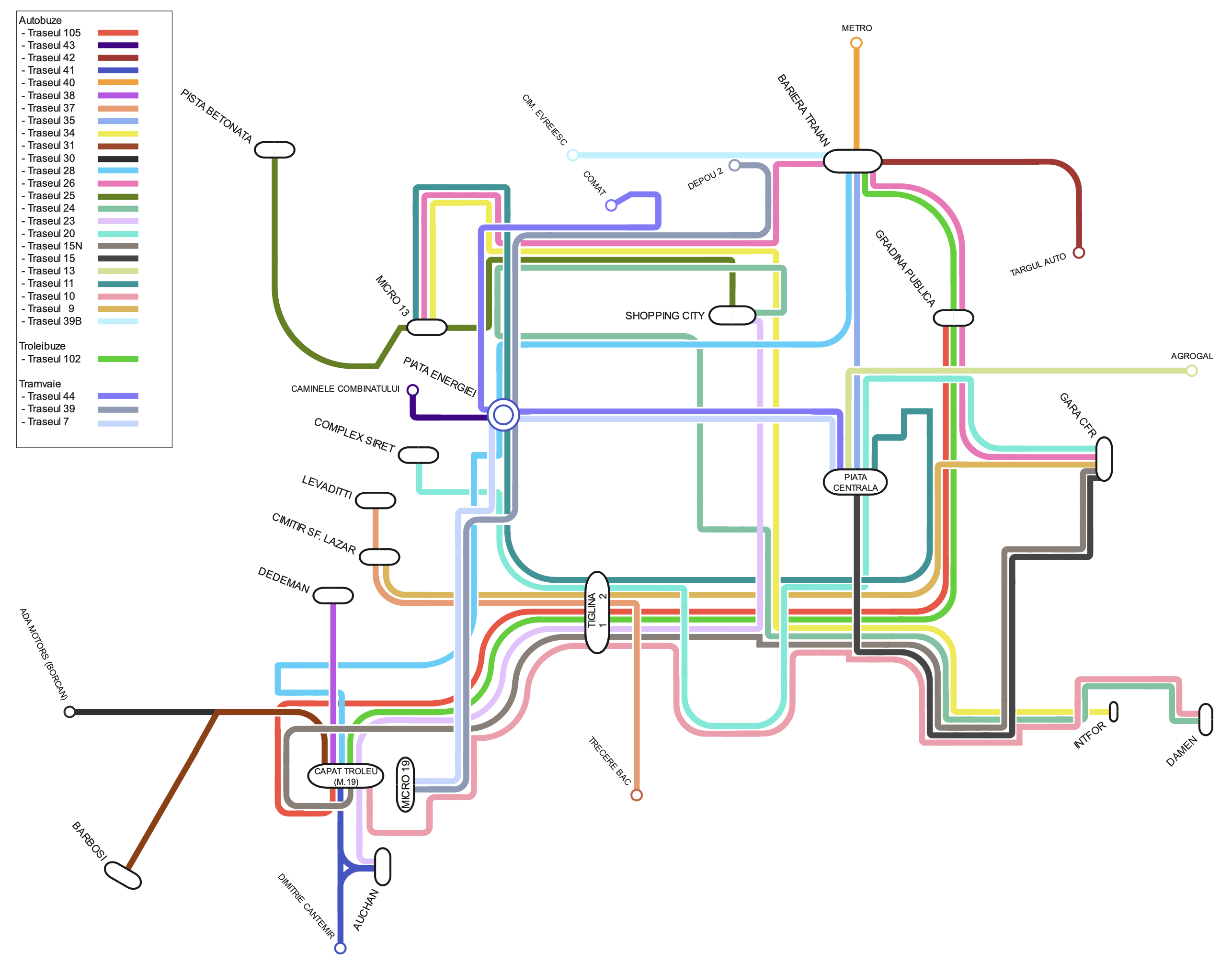
Galaţi — Maps
  GalaţiMaps
Map: TRANSURB S.A.

Nosūtījis Ymtram · East Haven - Branford           Datums: Jūnijs 2024 g.

Statistika

Publicēts 22.12.2024 21:09 MSK
Skatījumus — 390

Sīkāka informācija

Komentāri · 2

22.12.2024 21:19 MSK
Saite
Ymtram · East Haven - Branford
Foto: 20405 · Neautoru materiālu moderators / Foto moderators / Kopīgs redaktors / Ziņu redaktors / Vietnes tulkošana (EN)
The Galați's official operator's map is perhaps the worst example of mapping technique ever.

Please see the following map on urbanrail.net to figure out what is what (unfortunately maps at urbanrail.net are 'fluid', so readers in the future might get a different map upon clicking on this link):
https://www.urbanrail.net/eu/ro/galati/galati.htm

See a map of the more or less complete system in 2008 and 2010:
https://transphoto.org/photo/355550/
https://transphoto.org/photo/355565/

By 2024 following number of 'modernization' and 'optimization' projects, the tramway system has lost the line over the viaduct to CSG and the western industrial park, formerly the main passenger generator in the socialist times. The lines to Bariera, the Main Railway Station and to the eastern industrial park / Bazinul Nou are also lost. Only 3 branches and 3 tram services remain (routes 7,39,44) of the formerly sizeable operation. The trolleybus system now consists of a single route 102, while route 104 is no longer operated.
+3
+3 / –0
22.12.2024 21:48 MSK
Saite
Ymtram · East Haven - Branford
Foto: 20405 · Neautoru materiālu moderators / Foto moderators / Kopīgs redaktors / Ziņu redaktors / Vietnes tulkošana (EN)
Cхема маршрутов от официального оператора Галаца - пожалуй, худший пример техники картографии, какой можно придумать.

См. следующую карту на Urbanrail.net, чтобы понять, что к чему на официальной карте (к сожалению, карты на Urbanrail.net "флуидны" во времени, поэтому читатели в будущем, нажав на эту ссылку, могут получить другую карту):
https://www.urbanrail.net/eu/ro/galati/galati.htm

См. карту более-менее полной системы в 2008 и 2010 гг:
https://transphoto.org/photo/355550/
https://transphoto.org/photo/355565/

К 2024 году, после череды проектов "модернизации" и "оптимизации", трамвайная система потеряла линию, идущую через виадук к заводу CSG и западной промзоне, которая раньше была основным генератором пассажиропотока в социалистические времена. Линии до Bariera, ж.д. вокзал и на восточную промзону / Bazinul Nou также потеряны. От прежней значительной по размеру сети осталось только 3 ветки и 3 трамвайных маршрута (7,39,44). Троллейбусная система теперь состоит из одного маршрута 102, тогда как маршрут 104 больше не работает.
+2
+2 / –0

Jūsu komentārs

Diskusijas par politiku slēdzeni uz 1 mēnesi
Tu ne ienāci vietni.
Komentārus var atstāt tikai reģistrēti lietotāji.