TransPhoto

Fotografiile sunt publicate ca atare și nu au scopul de a promova vreo poziție politică și/sau ideologică.

Toate materialele sunt furnizate de către utilizatorii acestui site și nu reflectă opinia echipei de administrare a ste-ului

Închide
Cernăuți — Maps
  CernăuțiMaps

Publicat de Darius1 · Ottawa           Dată: 1911 an

Statistici

Publicat 10.11.2015 15:38 MSK
Vizualizări — 1629

Informație detaliată

Setările camerei foto

Arătați datele EXIF

Comentarii · 11

10.11.2015 23:55 MSK
Link
Святослав · Cernăuți
Fotografii: 603
Что это такое и откуда?
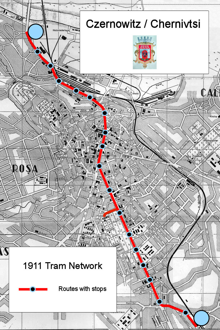
Карта времён румынской власти. Вверху наложены (не-в-тему) надписи Чернівці / Chernivtsi и нынешний герб Черновцов, а в нижней - обозначения на английском(???). В 1938 и город по другому называли (рум. - Cernăuți) и герб был иной.
+3
+4 / –1
11.11.2015 12:06 MSK
Link
Fotografii: 168
Цитата (Святослав, 10.11.2015):
> Что это такое

Схема трамвайной линии на 1938 год!
0
+1 / –1
11.11.2015 16:13 MSK
Link
Ymtram · East Haven - Branford
Fotografii: 20385 · Moderatorul fotografiilor terțe / Moderatorul fotografiilor / Redactor general / Redactor al știrilor / Traducerea interfeței (EN)
Unfortunately the map is incomplete. The branch to Bariera Comunala, opened in 192?, is not shown. The depot access line was actually used in revenue service. There were 3 different services, which fact is not reflected. I am also sincerely curious where did data on locations of stops come from. And it would be nice if the real name of the city a the time will be shown on the map - Cernăuți (Romanian). Many thanks.
0
+1 / –1
11.11.2015 23:01 MSK
Link
Darius1 · Ottawa
Fotografii: 10
Yury, You can find the locations of the tram stops here:
http://www.lvivcenter.org/en/umd/map/?ci_mapid=53
+1
+1 / –0
11.11.2015 23:17 MSK
Link
Ymtram · East Haven - Branford
Fotografii: 20385 · Moderatorul fotografiilor terțe / Moderatorul fotografiilor / Redactor general / Redactor al știrilor / Traducerea interfeței (EN)
Thanks for the link. The map via the link is from 1911, which explains absence of the Bariera Comunala branch on your map. Does it mean that your work should represent 1911, not 1938? The system appeared in the state depicted in your map between 16.12.1909 and 192?, provided we disregard the specific services operated.
+1
+1 / –0
12.11.2015 00:01 MSK
Link
Darius1 · Ottawa
Fotografii: 10
PLANUL MUNICIPIULUI CERNAUTI with the Bariera Comunala branch on the map:
http://www.mapywig.org/m/City_plans/Cent..._12.5K.jpg
unfortunately there is no date specified on the map
+1
+1 / –0
12.11.2015 04:51 MSK
Link
Ymtram · East Haven - Branford
Fotografii: 20385 · Moderatorul fotografiilor terțe / Moderatorul fotografiilor / Redactor general / Redactor al știrilor / Traducerea interfeței (EN)
This map was replaced with the 1911 version.
Схема заменена на версию по состоянию на 1911 г.
–1
+1 / –2
12.11.2015 22:56 MSK
Link
Святослав · Cernăuți
Fotografii: 603
Ооо... Ну ребята вы даёте... "Существенное" дополнение...
А это что такое?
Опять-же: карта времён румынской власти (на карте слева "ROȘA" написано на румынском(!!!) языке), а Черновцы до 1918 года были под Австро-Венгрией, и на карте все названия должны быть на немецком(!!!) языке. Ну а английский там вообще не-в-тему...
А за ссылки спасибо.
0
+1 / –1
13.11.2015 03:08 MSK
Link
Darius1 · Ottawa
Fotografii: 10
Святослав, could you go to the local library and find out where the four tramway lines were located?
0
+0 / –0
13.10.2024 00:43 MSK
Link
Пикачу · St Petersburg
Fotografii: 305
Почему закрыли трамвай в Черновцах?
0
+1 / –1
13.10.2024 00:46 MSK
Link
Oleg2020 · Berlin
Fotografii: 1
Цитата (Пикачу, 12.10.2024):
> Почему закрыли трамвай в Черновцах?

Через рельєф,не дочекавшись Татр Т4
Из-за рельефа,не дождавшись Татр Т4
0
+1 / –1

Comentariul dumneavoastră

Vă rugăm să nu aduceți în discuție subiecte politice, altfel veți fi suspendat pentru cel puțin o lună!
Trebuie să vă conectați pentru a scrie comentarii.