Maps
 |
Station Meir
Station Meir level -1 the East side station hall with map of the Antwerp Tram net.
Photo made on 12/11/2023.
January 17, 2022
Posted by AntwerpMetro
|
|
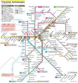
The scheme, valid from 08/12/2019.
The new routes (north of the city: Italiëlei — Noorderplaats and route to Havenhuis) will then be put into service. Route 24 will run to the Havenhuis and the historical route number 1 will come back, on the same route as long ago.
The temporary route 70 shall be cancelled and route 8 shall be shortened. Line 2 rides back to Hoboken, after major roadworks.
It is planned to revise the entire tram network by the end of 2020 or begin 2021.
December 8, 2019
Posted by focus1965
|
|
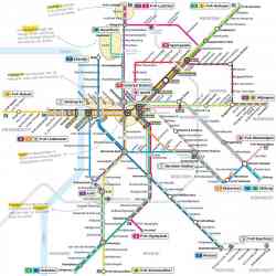
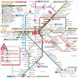
Map of tram in Antwerp.
Translation of remarks:
1: line 4 doesn't operate between Silsburg and Groenplaats due to roadworks till spring 2019
2: the same for line 24 which doesn't run between Silsburg and Stenenbrug.
Line 9 runs to P&R Wommelgem (before: line 8 which also use a complete other route due to the same roadworks).
3: line 2 will operate only till 'Zwaantjes' from july 2018.
4: line 12 will operate only between Schijnpoort and Centraal Station. Not on the map, but with former P.C.C. cars of Ghent!
April 3, 2018
Posted by focus1965
|
|
Трамвайная схема 2011 год
September 22, 2011
Author: DJHool
|
|
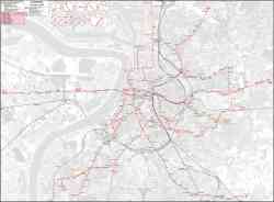
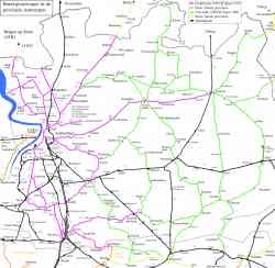
Map of the N.M.V.B./S.N.C.V. in and around Antwerpen in 1940 (non-electrified lines; green and yellow when out of the province) and 1952 (electrified lines; pink and orange when out of the province. Black = N.M.B.S./S.N.C.B. (railway).
https://nl.wikipedia.org/wiki/Buurtspoor...twerpen
1952
Posted by focus1965
|
Pictures displayed: 7 out of 7
Photos currently sorted by date (New photos listed first).
| 


 Urban Electric Transit