TransPhoto

Photos are published as is and do not have purpose to promote any political and/or ideological position.

All materials are provided by users and do not reflect the opinion of the site administration.

Close
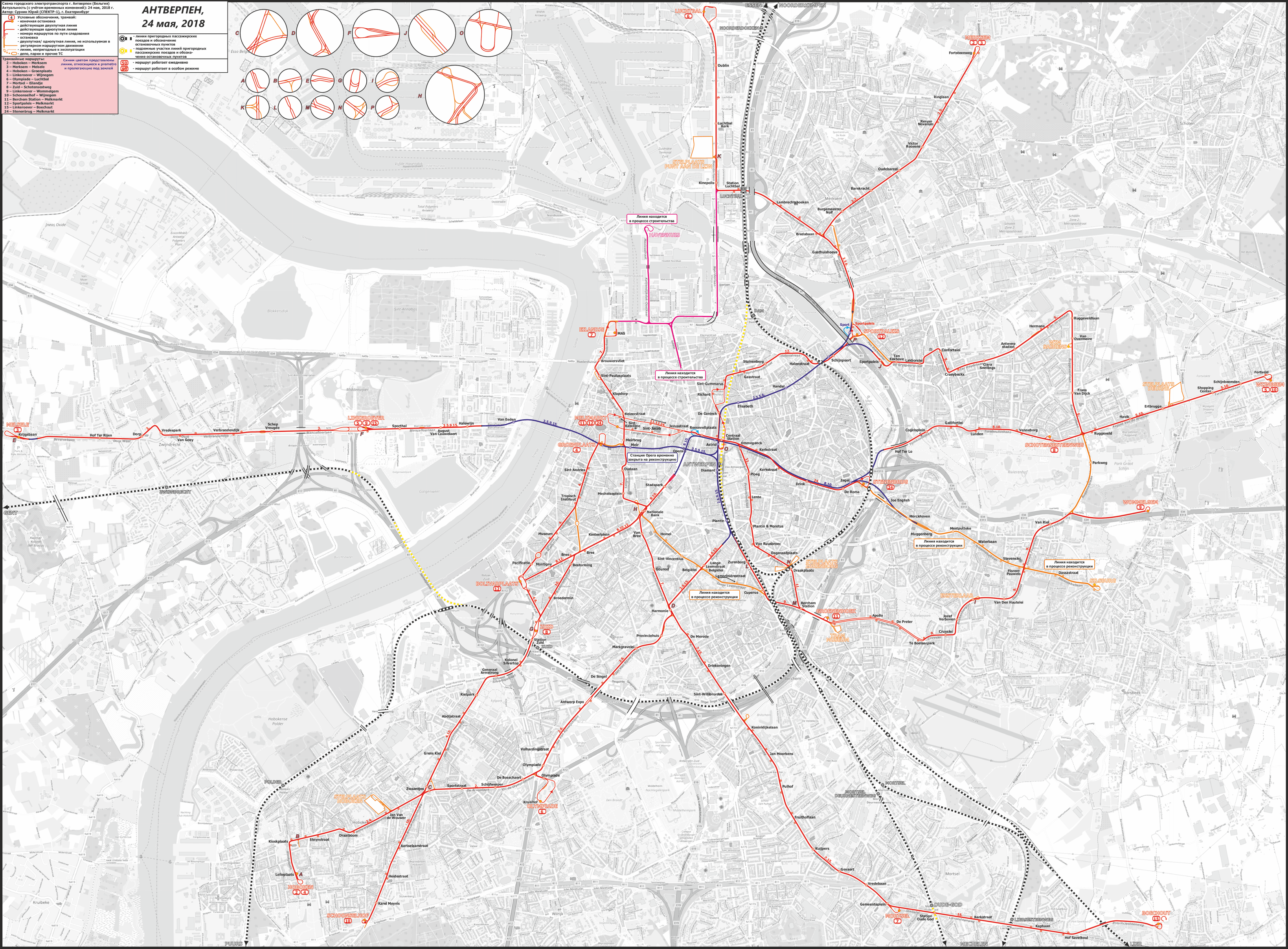
Antwerpen — Maps
  AntwerpenMaps

Autors: СПЕКТР-1           Datums: 24 maija 2018 g., ceturtdiena

Statistika

Publicēts 24.05.2018 23:14 MSK
Skatījumus — 2330

Sīkāka informācija

Komentāri · 10

25.05.2018 09:57 MSK
Saite
Foto: 288
Что такое синие линии?
0
+0 / –0
25.05.2018 13:04 MSK
Saite
Siachoquero · Tbilisi
Foto: 72
Цитата (Павел Зюзин, 25.05.2018):
> Что такое синие линии?

Подземные участки.
0
+0 / –0
25.05.2018 17:22 MSK
Saite
Foto: 46
Такая схема будет хорошим подспорьем в поездках по трамлиниям Антверпена на канале Ютуб.
+1
+1 / –0
25.05.2018 17:47 MSK
Saite
Foto: 253
Поспешу вас расстроить, но почти все на Ютубе уже неактуально. По измененным и свежеобновленным маршрутам работают сегодня: 4. 6. 8. 9. 12. 24.
0
+0 / –0
25.05.2018 19:49 MSK
Saite
focus1965 · Antwerpen
Foto: 7492 · Kopīgs redaktors / Vietnes tulkošana (EN/FR)
Good work and congratulations!

A couple of small remarks:

* line 12 no longer ends at the Bolivarplaats (Melkmarkt is correct).
* also in construction (pink lines): Frankrijklei and Italiëlei (only partialy on the map
* stelplaats 'Zurenborg' is since long closed. The tracks are used sporadic to park defect trams but only outside. Inside is used to park trucks. No more trams can enter in the buildings: just till outside.
* a 3th track exist on the stop 'Antwerp Stadion' to park extra trams for football, it is since long not more in use in normal service, but again: sometimes to park a defect tram or for a photostop by an excursion...

These are small details. The Antwerp network is now very volatile. Line 2 will be cut off in Hoboken next summer (due to roadworks) and today the trials started for line 70 (Eilandje - Luchtbal). But, back again, great work and many thanks! It's really better than the official one.
+2
+2 / –0
25.05.2018 21:26 MSK
Saite
Foto: 253
Thank you! I will try to correct mistakes in the nearest time or as soon as nearest changes happen.
+3
+3 / –0
07.06.2018 10:42 MSK
Saite
Foto: 168
Для полного счастья, я бы каким-то особым знаком показал ДАВНО построенные, но НЕИСПОЛЬЗУЕМЫЕ подземные(!!) станции. Их 5 на действующих участках: Carnot и Drink (между Astrid и Zegel), Collegelaan и Morckhoven (между Zegel и Muggenberg, тот участок показан как закрытый на реконструкцию) и Foorplein (между Zegel и Hof Ter Lo).

Более того, есть и целиком построенный в 1979-1985 годах подземный участок длиной около 1.4 км с ещё двумя станциями: Sint-Willibrordus и Stuivenberg.

Вот исчерпывающая схемка: https://commons.wikimedia.org/wiki/File:...tronet.jpg

Немного фотографий: https://www.lacourphotos.com/Underground/Pre-Metro/

Более подробно - в Нидерландской Википедии: https://nl.wikipedia.org/wiki/Antwerpse_...'_premetro

З.Ы. Заинтриговался я Антверпеном и полез смотреть космоснимки. Судя по всему, строящаяся линия по бульвару "Italiëlei" будет тоже опускаться под землю и вливаться в подземный участок в районе станции "Опера". Явно видна строящаяся рампа тоннеля.
+1
+1 / –0
08.06.2018 07:36 MSK
Saite
Foto: 253
Цитата (Мистер Гуй, 07.06.2018):
> построенный в 1979-1985 годах подземный участок

Мне показалось, что он перспективный. Даже в голову не пришло, что он вполне себе существующий! Спасибо!
0
+0 / –0
08.06.2018 23:02 MSK
Saite
focus1965 · Antwerpen
Foto: 7492 · Kopīgs redaktors / Vietnes tulkošana (EN/FR)
Quote (Мистер Гуй, 07.06.2018):
>
> З.Ы. Заинтриговался я Антверпеном и полез смотреть космоснимки. Судя по всему, строящаяся линия по бульвару "Italiëlei" будет тоже опускаться под землю и вливаться в подземный участок в районе станции "Опера". Явно видна строящаяся рампа тоннеля.

Everything what you wrote is true, but only this above not. The part of the Italiëlei is not build underground. The Frankrijlei is for a part underground (now in use for line 8 and 10) and the reconstruction of the line in the street go together with the complete reconstruction of the area and the line to the Italiëlei. Work is still in progress but no more tunnels are planned. Only the unused tunnels under the Kerkstraat is (back again) planned to be used one or another day and could be seen at a new trammap for 2020. This map is only a project. The use of the stations that are not finished is not planned for the next years...
0
+0 / –0
21.09.2018 14:40 MSK
Saite
Foto: 253
Line 70 was opened at 15th September with route from Eilandje MAS to Kinepolis.
0
+0 / –0

Jūsu komentārs

Diskusijas par politiku slēdzeni uz 1 mēnesi
Tu ne ienāci vietni.
Komentārus var atstāt tikai reģistrēti lietotāji.